
Evacuation ORDER issued for East Side of Sugar Lake
Based upon recommendation from the BC Wildfire Service, the Regional District of North Okanagan (RDNO) at the Emergency Operations Centre has issued an Evacuation ORDER for the east side of Sugar Lake, especially for the seasonal recreation properties within Sugar Lake Resort located at 1630 Sugar Lake Road due to the Sitkum Creek wildfire (#K41109), previously on alert.
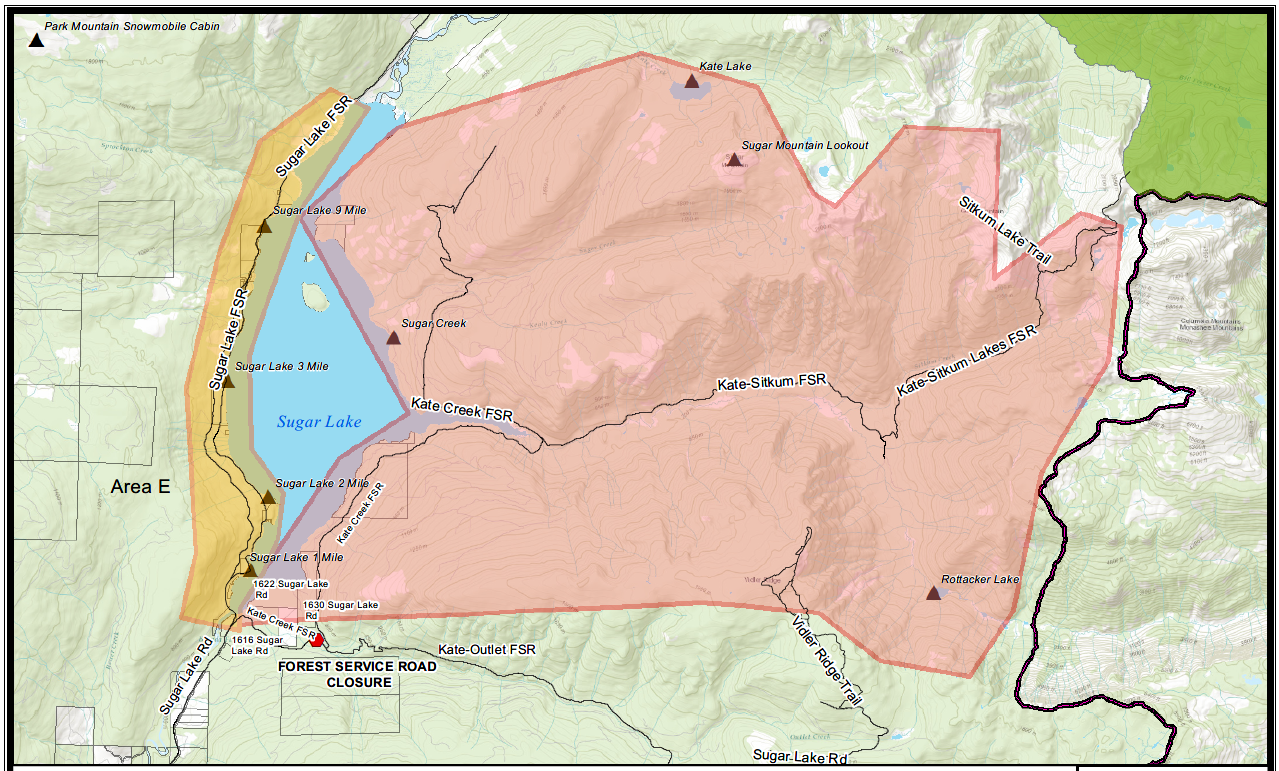
Members of the RCMP will be expediting the Evacuation Order. Evacuees will not have access to their properties while the Order is in place; therefore, bring your pets and important items with you. See Evacuation Order area map attached (red polygon).
Because of the immediate danger to life safety, the Evacuation ORDER includes the following areas:
All lands east of Sugar Lake, from the southern end to the northern tip, and from the east shore to a line north south-through Initiative Peak. This region includes all sites within Sugar Lake Resort at 1630 Sugar Lake Road
IF YOU ARE IN THIS AREA, YOU MUST LEAVE THE AREA IMMEDIATELY.
WHAT YOU SHOULD DO:
- If you have a functioning, self-contained RV, and time permits, residents are encouraged to bring their RVs with them as accommodations are limited.
- Shut off all gas and electrical appliances, other than refrigerators and freezers.
- Close all windows and doors.
- Close gates (latch) - but do not lock.
- Take critical items (medicine, purse, wallet, and keys) only if they are immediately available. Take pets in pet kennels or on leash.
- Gather your family and, if you have room, take a neighbour or someone needing transportation. Do not use more vehicles than you have to.
- Do not use the telephone unless you need emergency services.
- Follow the evacuation route provided as follows: Kate Creek FSR to Sugar Lake Road towards Cherryville.
For an interactive map showing the Evacuation areas, please visit our online wildfire map portal.
Evacuation ALERT issued for West side of Sugar Lake
In addition to the above Evacuation Order, based upon recommendation from the BC Wildfire Service, an Evacuation ALERT has been issued by Regional District North Okanagan (RDNO) at the Emergency Operations Centre for the west side of Sugar Lake due to the wildfire at Sitkum Creek (#K41109).
Because of the potential danger to life and health, and a number of recreation sites within the proximity of Sugar Lake, the RDNO has issued an Evacuation Alert for the following areas:
All recreational properties located on the west shore of Sugar Lake
This has been implemented to limit access to the Evacuation Alert area. Due to limited evacuation escape routes, travel through the Evacuation Alert Area to Spectrum or Greenbush Lake is not recommended. If an Evacuation Order is required for the area, there are limited routes back to safety.
Residents will be given as much advance notice as possible prior to evacuation; however, you may receive limited notice due to changing conditions. Please note: The attached map is a general guideline. Any property near the area should be prepared, and ready to evacuate during threatened times. See Evacuation Alert Area map attached (yellow polygon).
WHAT YOU SHOULD DO:
- Locate family members and designate a meeting area outside the evacuation area should an Evacuation Order be called while separated.
- Pack essential items such as government issued ID, medications, eyeglasses, valuable papers, immediate care needs for dependents and, if time and space permits, keepsakes for quick departure.
- Prepare to move persons with disabilities, children or neighbours, if assistance is needed.
- Prepare to take pets with you and move livestock to a safe area (if possible).
- Arrange transportation for all household members. Fill the gas tanks of personal vehicles.
- Arrange accommodation for all members of the residence, if possible.
- Wait for an Evacuation Order to be issued before evacuating.
- Monitor the news, radio and online sources for information on evacuation orders.
Further information will be issued as updates are received from the BC Wildfire Service. Residents are encouraged to visit www.rdno.ca, the RDNO Facebook page, and listen to local radio for more information.
For an interactive map showing the Evacuation areas, please visit our online wildfire map portal.
– 30 –
For media inquiries:
Stacey Raftus, EOC Information Officer
250-550-3712 | stacey.raftus@rdno.ca