Home → News → Media Releases
Evacuation Alert RESCINDED for Winnifred Creek
Posted Thursday, August 26, 2021
August 26, 2021, 11:45 hrs
Based upon recommendation from the BC Wildfire Service, the Regional District of North Okanagan is rescinding the Evacuation Alert for properties along the East Kettle River Forest Service Road and Keefer Lake Road due to the Winnifred Creek fire (#K42042)
Properties rescinded from the Evacuation Alert include:
Properties along Highway 6, 15km east of Cherryville – 25km east of Cherryville
Properties on the East Kettle River FSR, Kettle River Mainline Road, Keefer Lake Road, including the Keefer Lake Area.
Residents are reminded that although the Evacuation Alert has been removed, the Province of British Columbia is still facing threat of wildfire in the area. We encourage you to stay connected with up to date information and remain aware of current situations and weather conditions.
Further information will be issued as updates are received from the BC Wildfire Service. RDNO residents are encouraged to visit www.rdno.ca, and the RDNO Facebook page for more information. A detailed map of all Evacuation Alerts and Orders in the area can be found at EmergencyMapBC.
Issued July 20, 2021
Based upon the recommendation from the BC Wildfire Service, an Evacuation Alert has been issued by Regional District North Okanagan (RDNO) at the Emergency Operations Centre (EOC) due to a wildfire on the East Kettle River Fire Service Road, Keefer Lake Road (#K42042).
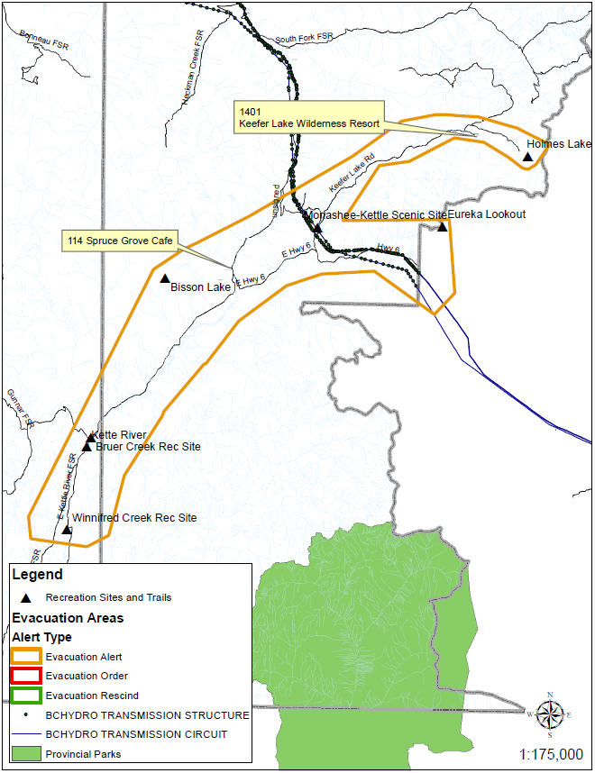
Because of the potential danger to life and health including a threat to infrastructure, the RDNO has issued an Evacuation Alert for the following areas:
Highway 6, 15km east of Cherryville – 25km east of Cherryville
East Kettle River FSR, Kettle River Mainline Rd, Keefer Lake Rd, including Keefer Lake Area.
*See map of Evacuation Alert area below*
An Evacuation Alert has been issued to prepare you to evacuate your premises, property or recreational areas within the mapped region should it be found necessary. Residents will be given as much advance notice as possible prior to evacuation; however you may receive limited notice due to changing conditions.
Please note: This map is not specific to any particular address within the shown evacuation alert boundary, but a general guideline. Any property in close proximity to the wildland should be prepared, and ready to evacuate during threatened times.
WHAT YOU SHOULD DO:
- Locate all family members and designate a meeting area outside the evacuation area, should an Evacuation Order be called while separated.
- Pack essential items such as government issued ID, medications, eyeglasses, valuable papers (e.g. insurance, credit, and mortgage information), immediate care needs for dependents and, if time and space permits, keepsakes for quick departure.
- Prepare to move persons with disabilities, children and/or neighbours, if assistance is needed.
- Prepare to take pets with you and move livestock to a safe area (if possible).
- Arrange transportation for all your household members. Fill the gas tanks of personal vehicles.
- Arrange accommodation for all members of the residence, if possible.
- Wait for an Evacuation Order to be issued before evacuating.
- Monitor the news, radio and online sources for information on evacuation orders and location of Reception Centres.
Further information will be issued July 21, 2021 @ 12:00 hrs (noon), or visit www.rdno.ca, the RDNO Facebook page, and local radio for more information.