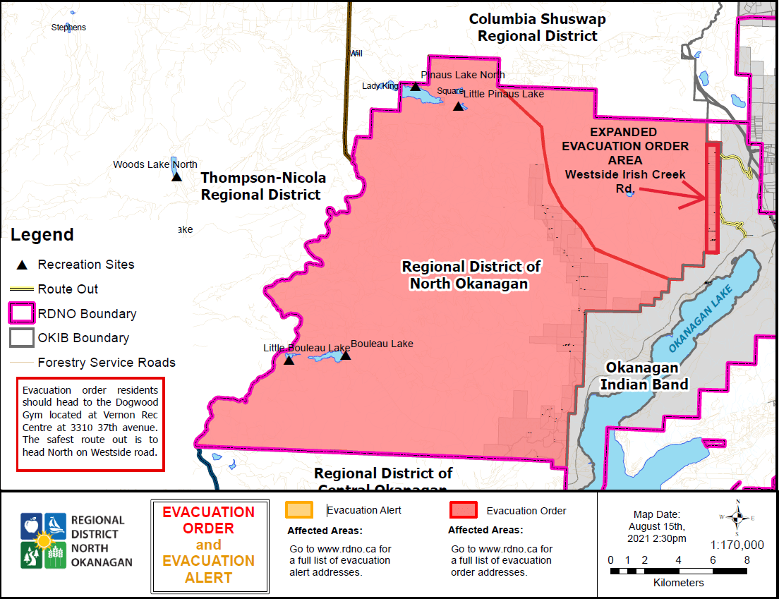
August 15, 18:25 hrs
Based upon recommendation from the BC Wildfire Service, the Regional District of North Okanagan (RDNO) has again expanded the Evacuation ORDER for a portion of Electoral Area B above Westside Road. The Order now includes properties located on the west side of Irish Creek Road and Beatrice Road due to the White Rock Lake wildfire (#K61884).
This Evacuation Order includes all 20 properties on the west side of Irish Creek Road and Beatrice Road, previously on Evacuation Alert and not within the Okanagan Indian Band IR#1.
Addresses include:
• 257, 259 (aka 59 Beatrice Road), 280, 300, 304, 306, 396, 398, 424, 570, 576, 590, 610, 614, 620, 640, 644, 664, 668, 678 of Irish Creek Road.
Update August 13, 14:20 hrs - The RDNO has issued an update on the current wildfire situation affecting our electoral areas, including the White Rock Lake wildfire, Bunting Road wildfire and Winnifred Creek wildfire. All Alerts and Orders remain in place.
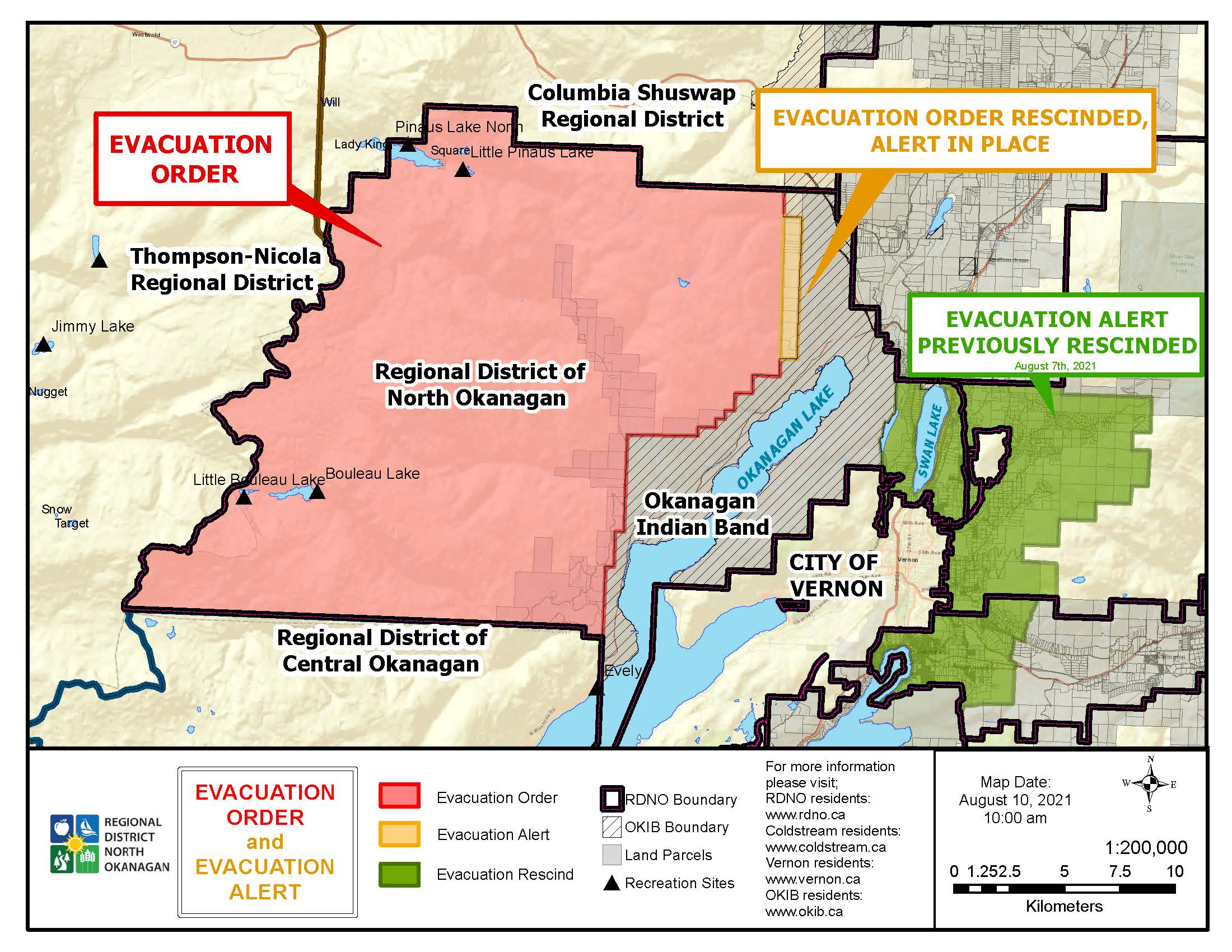
Evacuation Order RESCINDED for Irish Creek Road. Evacuation Order Remains in Place for other Properties within the RDNO on the west side of Okanagan Lake
August 10, 10:25 hrs
The Evacuation Order issued for the west side of Irish Creek Road within Electoral Area ‘B’ by the Regional District of North Okanagan through the Emergency Operations Centre due to the danger to life safety caused by the White Rock Lake wildfire has now been rescinded.
All homes in the rescind area revert to Evacuation ALERT status and residents must remain ready to leave their homes again on short notice if the fire situation changes.
The area downgraded to Evacuation Alert status includes 20 properties on the west side of Irish Creek Road and Beatrice Road that are not within the Okanagan Indian Band IR#1.
Addresses include:
- 257, 259, 280, 300, 304, 306, 396, 398, 424, 570, 576, 590, 610, 614, 620, 640, 644, 664, 668, 678 of Irish Creek Road
Please see the map below.
An Evacuation Order may need to be re-issued and, if deemed necessary, the Evacuation Order process with re-commence. While residents return to their homes and remain on Evacuation Alert, the following should be considered in preparation if a subsequent Evacuation Order be issued.
WHAT YOU SHOULD DO:
- Locate family members and designate a meeting area outside the evacuation area should an Evacuation Order be called while separated.
- Pack essential items such as government issued ID, medications, eyeglasses, valuable papers, immediate care needs for dependents and, if time and space permits, keepsakes for quick departure.
- Prepare to move persons with disabilities, children or neighbours, if assistance is needed.
- Prepare to take pets with you and move livestock to a safe area (if possible).
- Arrange transportation for all household members. Fill the gas tanks of personal vehicles.
- Arrange accommodation for all members of the residence, if possible.
- Wait for an Evacuation Order to be issued before evacuating.
- Monitor the news, radio and online sources for information on evacuation orders and location of Reception Centres.
The Evacuation ORDER issued for the remaining properties in Electoral Area ‘B’ located on the west side of Okanagan Lake remains in effect including:
- 140, 464 of Whiteman Creek Road
- 442, 503, 545, 550, 560, 651, 655, 659, 661, 730, 735, 801, 809, 878, 890, 901, 1001, 1070, 1075, 1135, 1195, 1221, 1250, 1470 of Six Mile Creek Road
- 351, 425, 252, 631, 635, 400 block of Nashwito Road
- 485, 17, 65 of Cain Road
- 1100 Bouleau Lake Road
- 75, 79, 305, 311, 315 of Beau Park Road
- 10, 15, 50, 93 of Banks Road
- 221, 225, 235, 267, 278 Siwash Creek Road
- All premises on Bouleau Lake
- All premises on Pinaus Lake
Please see the map below.
Further information will be issued as updates are received from the BC Wildfire Service. RDNO residents are encouraged to continue to visit www.rdno.ca, and the RDNO Facebook page for more information. A detailed map of all Evacuation Alerts and Orders in the area can be found at EmergencyMapBC.
Update, August 9, 12:33 hrs
The Evacuation Order for RDNO properties due to the White Rock Lake Fire remains in effect. The Evacuation Order area includes:
- North and East of, and including Pinaus Lake – running South to include Bouleau Lake
- East and South of Bouleau Lake – running west to the Thompson Nicolas Regional District Evacuation Alert and Order (South and parallel to Salmon River Fire Service Road)
Addresses include:- 15 Seasonal Dwelling Units on Bouleau Lake Road
- 6376, 6382, 6386, 6396, 6392 on Pinaus Lake Forest Service Road
- Electoral Area B: east of Thompson Nicola Regional District and Columbia Shuswap Regional District (CSRD), north of Central Okanagan Regional District, west of Okanagan Indian Band Territory IR#1, and south of CSRD.
Addresses include:- 140 Whiteman creek Road
- 442, 503, 545, 550, 560, 651, 655, 659, 661, 730, 735, 801, 809, 878, 890, 901, 1001, 1070, 1075, 1135, 1195, 1221, 1250, 1470 of Six Mile Creek Road
- 351, 425, 252, 631, 635, 400 block of Nashwito Road
- 194, 304, 396, 398, 424, 570, 576, 580, 590, 610, 614, 620, 640, 644, 664, 668, 678, 749, 257, 259, 280, 300, 306 of Irish Creek Road
- 485, 17, 65 Cain Road
- 1100 Bouleau Lake Road
- 305 Beau Park Road
- 59 Beatrice Road
- 10, 15, 50, 93 of Banks Road
- 659 6 Mile Creek Road
- Irish Creek Road including - 194, 304, 396, 398, 424, 570, 576, 580, 590, 610, 614, 620, 640, 644, 664, 668, 678, 749, 257, 259, 280, 300, 306
IF YOU ARE IN THIS AREA YOU MUST LEAVE IMMEDIATELY.
Further information will be issued as updates are received from the BC Wildfire Service. Residents are encouraged to visit www.rdno.ca, the RDNO Facebook page, and listen to local radio for more information.
If you require information on properties within the Columbia Shuswap Regional District, Thompson-Nicola Regional District, Regional District of Central Okanagan or the Okanagan Indian Band, please refer to their corresponding websites.
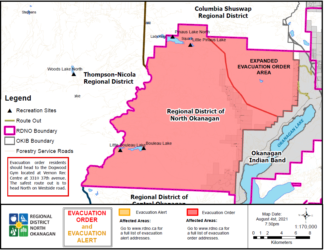
Update, August 4, 21:38 hrs (9:38PM) Evacuation ORDER Expanded to Irish Creek Road due to White Rock Lake Fire
Evacuation ORDER Expanded to Irish Creek Road due to White Rock Lake Fire
Based upon recommendation from the BC Wildfire Service, the Regional District of North Okanagan (RDNO) has expanded the Evacuation ORDER for a portion of Electoral Area B above Westside Road. The Order now includes properties located on the west side of Irish Creek Road and Beatrice Road due to the White Rock Lake wildfire (#K61884).
The Evacuation Order previously issued for properties along Bouleau and Pinaus Lake as well as properties south of Six Mile Creek Road remain in effect.
Because of the immediate danger to life safety, the Evacuation Order includes the following areas:
South of the Columbia Shuswap Regional District southern boundary, west of the Okanagan Indian Band Reserve #1, north and east of Six Mile Creek Road, Pinaus Lake FSR and Pinaus-Square Lake FSR
This includes all properties on the west side of Irish Creek Road and Beatrice Road and not within the OKIB #1
Addresses include:
304, 396, 398, 424, 570, 576, 590, 610, 614, 620, 640, 644, 664, 668, 678, 257, 280, 300, 306 of Irish Creek Road
Members of the local police department and other applicable agencies will be expediting the Evacuation Order. Evacuees will not have access to their houses while the Order is in place; therefore, bring your pets and important items with you. See Evacuation Order area map attached.
IF YOU ARE IN THIS AREA, YOU MUST LEAVE THE AREA IMMEDIATELY.
What you should do:
- If you have a functioning, self-contained RV, and time permits, residents are encouraged to bring their RVs with them as accommodations are limited.
- Shut off all gas and electrical appliances, other than refrigerators and freezers.
- Close all windows and doors.
- Close gates (latch) - but do not lock.
- Take critical items (medicine, purse, wallet, and keys) only if they are immediately available. Take pets in pet kennels or on leash.
- Gather your family and, if you have room, take a neighbour or someone needing transportation. Do not use more vehicles than you have to.
- Do not use the telephone unless you need emergency services.
- Follow the evacuation route provided as follows:
- Travel north on Irish Creek Road, then east and south onto Hwy 97 to Vernon.
- If you are travelling south on Irish Creek Road, follow it to Westside Road, then east to Hwy 97 and south to Vernon.
- If you are travelling on Beatrice Road, head north to Irish Creek Road, then east and south to Westside Road, east to Hwy 97 and south to Vernon.
- To register with Emergency Support Services on August 4 – Go to the ESS Reception Centre located at the OKIB Hall at 12420 Westside Road.
- To register with Emergency Support Services on August 5 – Go to the ESS Reception Centre located at the Dogwood Gym, Vernon Recreation Centre located at 3310 37 Ave, Vernon.
- Evacuees can also register online at https://ess.gov.bc.ca/. Important: leave the area before registering.
The White Rock Lake wildfire spans through the Thompson-Nicola Regional District, Regional District of Central Okanagan, Columbia Shuswap Regional District, and the Okanagan Indian Band. Please visit their websites for local information.
The RDNO thanks the Okanagan Indian Band and the City of Vernon for their support in providing space for the ESS reception, and also thanks the City of Armstrong and the Township of Spallumcheen for their collaboration and support.
Further information will be issued as updates are received from the BC Wildfire Service. Residents are encouraged to visit www.rdno.ca, the RDNO Facebook page, and listen to local radio for more information.
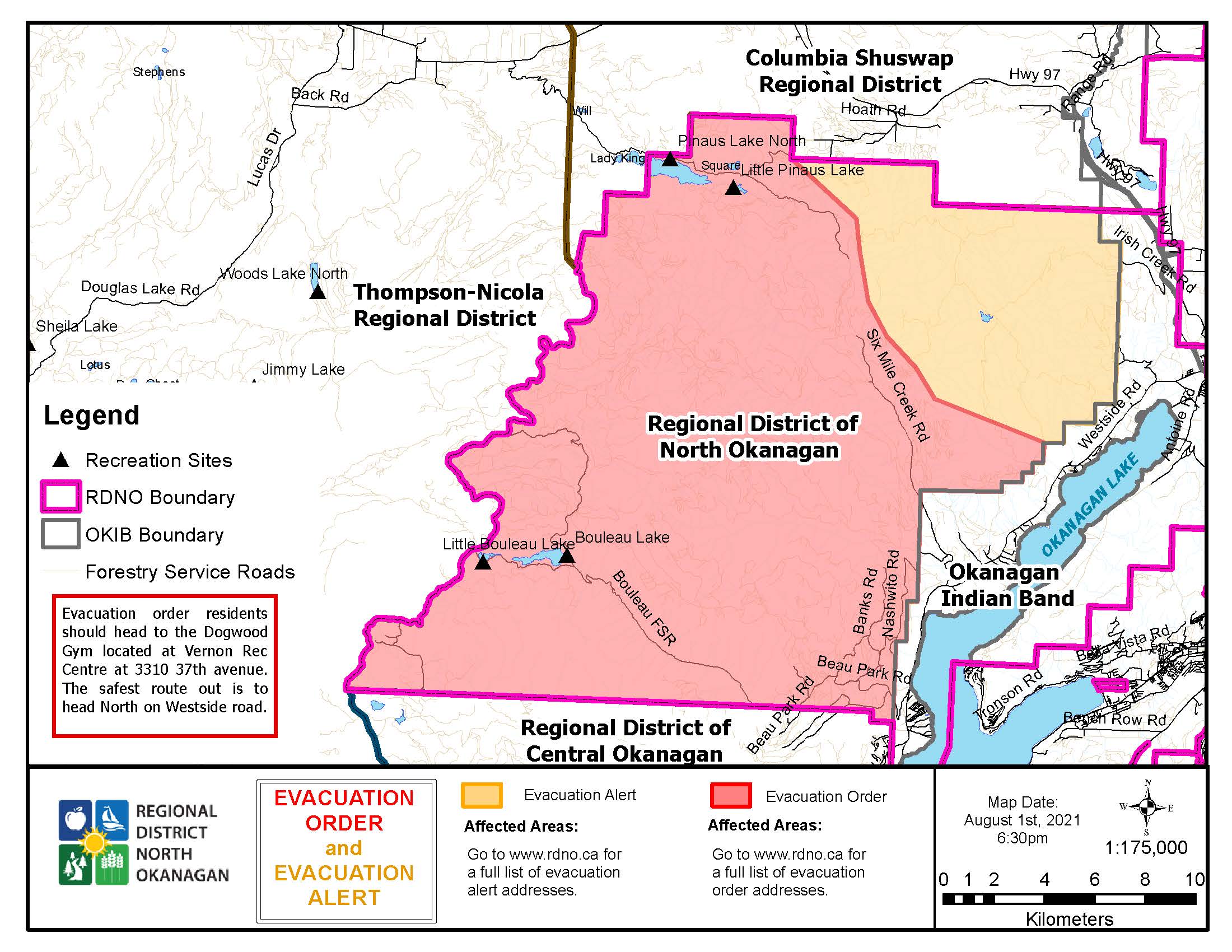
Update, August 1, 19:53 hrs (7:53PM) Evacuation ORDER issued for Properties South of Six Mile Creek Road in Electoral Area B (above Westside Road) due to White Rock Lake Fire
Based upon the recommendation from the BC Wildfire Service, the Regional District of North Okanagan (RDNO) has issued an Evacuation ORDER for a portion of Electoral Area B above Westside Road. The Order applies to all of the properties south of and including Six Mile Creek Road to the boundary of the Regional District of Central Okanagan due to the White Rock Lake wildfire (#K61884).
The Evacuation ORDER previously issued for properties along Bouleau and Pinaus Lake remains in effect. The Evacuation ALERT for properties along Irish Creek Road in Electoral Area B remains in effect.
EVACUATION ORDER
Members of the local police department and other applicable agencies will be expediting the Evacuation Order. Evacuees will not have access to their houses while the Order is in place; therefore, bring your pets and important items with you. See Evacuation Order/Alert area map attached.
Because of the immediate danger to life safety, the Evacuation ORDER includes the following areas:
Portion of Electoral Area 'B' in the Regional District of North Okanagan above Westside Road, north of the Regional District of Central Okanagan boundary, west of the Okanagan Indian Band IR#1, and south and west of Six Mile Creek road
Addresses:
464, 140 of Whiteman Creek Road
442, 503, 545, 550, 560, 651, 655, 659, 661, 730, 735, 801, 809, 878, 890, 901, 1001, 1070, 1075, 1135, 1195, 1221, 1250, 1470 of Six Mile Creek Road
485, 351, 425, 252, 631, 635 of Nashwito Road
17, 65 Cain Road
305, 311, 315, 79, 75 of Beau Park Road
59 Beatrice Road
10, 15, 50, 93 of Banks Road
278, 267, 225, 221, 235 of Siwash Creek Road
The Evacuation ORDER for 15 Seasonal Dwelling Units on Bouleau Lake Road, and 6376, 6382, 6386, 6396, 6392 on Pinaus Lake Forest Service Road remains in place.
IF YOU ARE IN THIS AREA, YOU MUST LEAVE THE AREA IMMEDIATELY.
What you should do:
- If you have a functioning, self-contained RV, and time permits, residents are encouraged to bring their RVs with them as accommodations are limited.
- Shut off all gas and electrical appliances, other than refrigerators and freezers.
- Close all windows and doors.
- Close gates (latch) - but do not lock.
- Take critical items (medicine, purse, wallet, and keys) only if they are immediately available. Take pets in pet kennels or on leash.
- Gather your family and, if you have room, take a neighbour or someone needing transportation. Do not use more vehicles than you have to.
- Do not use the telephone unless you need emergency services.
- Follow the evacuation route provided as follows:
- Travel east onto Westside road then head north to head of the lake.
- Continue east and south on highway 97 to Vernon. Register with Emergency Support Services at the Vernon ESS Reception Centre (Dogwood Gym): 3409 35th Avenue.
- Evacuees can also register online at https://ess.gov.bc.ca/.
- Important: leave the area before registering
The RDNO thanks the City of Vernon for their support in providing the space for the ESS reception, and also thanks the City of Armstrong and the Township of Spallumcheen for their collaboration and support.
EVACUATION ALERT
Because of the potential danger to life and health, in addition to the above Evacuation Order the existing Evacuation Alert for the following addresses remains in effect:
194, 304, 396, 398, 424, 570, 576, 580, 590, 610, 614, 620, 640, 644, 664, 668, 678, 749, 257, 259, 280, 300, 306 of Irish Creek Road
An Evacuation Alert has been issued to prepare you to evacuate your premises, property or recreational site within the mapped area should it be found necessary. Residents will be given as much advance notice as possible prior to evacuation; however you may receive limited notice due to changing conditions.
Please note: The map is not specific to any particular address within the evacuation alert boundary, but a general guideline. Any property in close proximity to the area should be prepared, and ready to evacuate during threatened times. See map of Evacuation Order/Alert area attached.
What you should do:
- Locate family members and designate a meeting area outside the evacuation area should an Evacuation Order be called while separated.
- Pack essential items such as government issued ID, medications, eyeglasses, valuable papers, immediate care needs for dependents and, if time and space permits, keepsakes for quick departure.
- Prepare to move persons with disabilities, children or neighbours, if assistance is needed.
- Prepare to take pets with you and move livestock to a safe area (if possible).
- Arrange transportation for all household members. Fill the gas tanks of personal vehicles.
- Arrange accommodation for all members of the residence, if possible.
- Wait for an Evacuation Order to be issued before evacuating.
- Monitor the news, radio and online sources for information on evacuation orders and location of Reception Centres.
The White Rock Lake wildfire spans through the Thompson-Nicola Regional District, Regional District of Central Okanagan, Columbia Shuswap Regional District, and the Okanagan Indian Band, so please visit their websites for local information.
Further information will be issued as updates are received from the BC Wildfire Service. Residents are encouraged to visit www.rdno.ca, the RDNO Facebook page, and listen to local radio for more information.
Update - July 30, 15:45 - The RDNO has issued an update on the current wildfire situation in our region and nearby.
July 27, 13:47 hrs - Evacuation Order Issued for Pinaus Lake, South to Bouleau Lake, with Additional Evacuation Alert Issued
Based upon the recommendation from the BC Wildfire Service, the Regional District of North Okanagan has issued an Evacuation Order due to a wildfire at White Rock Lake (#K61884). In addition to issuing the Order an Evacuation Alert has been issued for the neighbouring area.
EVACUATION ORDER
Members of the local police department and other applicable agencies will be expediting the Evacuation Order. Evacuees will not have access to their houses while the Order is in place; therefore, bring your pets and important items with you. See Evacuation Order/Alert area map attached.
Because of the immediate danger to life safety, the Evacuation Order includes the following areas:
North and east of, and including Pinaus Lake, running south to include Bouleau Lake, east and south of Bouleau Lake and then west to the Thompson Nicola Regional District areas of evacuation alert and order (south of and parallel to Salmon River Forest Service Road).
The area includes multiple recreation sites in proximity of Pinaus Lake and Bouleau Lakes.
The Evacuation ORDER applies to approximately 20 properties, including seasonal dwellings. The addresses are:
15 Seasonal Dwelling Units on Bouleau Lake Road
6376, 6382, 6386, 6396, 6392 on Pinaus Lake Forest Service Road
IF YOU ARE IN THIS AREA, YOU MUST LEAVE THE AREA IMMEDIATELY.
WHAT YOU SHOULD DO:
- Shut off all gas and electrical appliances, other than refrigerators and freezers.
- Close all windows and doors.
- Close gates (latch) - but do not lock.
- Take critical items (medicine, purse, wallet, and keys) only if they are immediately available. Take pets in pet kennels or on leash.
- Gather your family and, if you have room, take a neighbour or someone needing transportation. Do not use more vehicles than you have to.
- Do not use the telephone unless you need emergency services.
- Follow the evacuation route provided as follows:
- From Pinaus Lake area: travel east along the Pinaus-Square Lake Forest Service Road (6020.03). This route connects to Cedar Hill Road, a public road, and junctions with Provincial Highway 97.
- From Bouleau lake: travel east on Bouleau Forest Service Road to Whiteman Creek Forest Service Road, heading northeast to Westside Road.
- Once you are evacuated, register as an evacuee online at https://ess.gov.bc.ca
EVACUATION ALERT
Because of the potential danger to life and health, in addition to the above Evacuation Order the RDNO has issued an Evacuation Alert for the following areas:
Electoral Area B: east of Thompson Nicola Regional District and Columbia Shuswap Regional District (CSRD), north of Central Okanagan Regional District, west of Okanagan Indian Band Territory IR#1, and south of CSRD.
The addresses are:
140 Whiteman creek Road
442, 503, 545, 550, 560, 651, 655, 659, 661, 730, 735, 801, 809, 878, 890, 901, 1001, 1070, 1075, 1135, 1195, 1221, 1250, 1470 of Six Mile Creek Road
351, 425, 252, 631, 635, 400 block of Nashwito Road
194, 304, 396, 398, 424, 570, 576, 580, 590, 610, 614, 620, 640, 644, 664, 668, 678, 749, 257, 259, 280, 300, 306 of Irish Creek Road
485, 17, 65 Cain Road
1100 Bouleau Lake Road
305 Beau Park Road
59 Beatrice Road
10, 15, 50, 93 of Banks Road
659 6 Mile Creek Road
An Evacuation Alert has been issued to prepare you to evacuate your premises, property or recreational site within the mapped area should it be found necessary. Residents will be given as much advance notice as possible prior to evacuation; however, you may receive limited notice due to changing conditions.
See map of Evacuation Alert area attached. Please note: The attached map is not specific to any particular address within the evacuation alert boundary but a general guideline. Any property in close proximity to the area should be prepared and ready to evacuate during threatened times.
WHAT YOU SHOULD DO:
- Locate family members and designate a meeting area outside the evacuation area should an Evacuation Order be called while separated.
- Pack essential items such as government-issued ID, medications, eyeglasses, valuable papers, immediate care needs for dependents and, if time and space permits, keepsakes for quick departure.
- Prepare to move persons with disabilities, children or neighbours, if assistance is needed.
- Prepare to take pets with you and move livestock to a safe area (if possible).
- Arrange transportation for all household members. Fill the gas tanks of personal vehicles.
- Arrange accommodation for all members of the residence, if possible.
- Wait for an Evacuation Order to be issued before evacuating.
- Monitor the news, radio and online sources for information on evacuation orders and location of Reception Centres.
Further information will be issued as updates are received from the BC Wildfire Service. Residents are encouraged to or visit www.rdno.ca, the RDNO Facebook page, and listen to local radio for more information.
The White Rock Lake wildfire spans across the boundaries of multiple local governments, regional districts, and first nations. The RDNO can only speak to affected areas within our boundaries; therefore, if you are in this area but outside the boundaries of the RDNO, please check in with your local authority for information about Alerts and Orders.
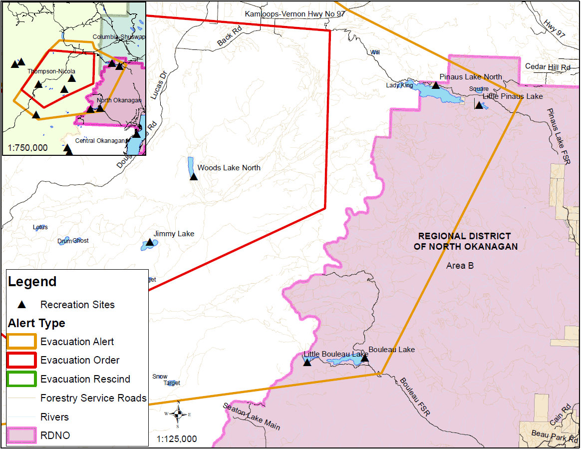
July 26 - Based upon recommendation from the BC Wildfire Service, an Evacuation Alert has been issued by Regional District North Okanagan (RDNO) at the Emergency Operations Centre due to a wildfire at White Rock Lake (#K61884).
Because of the potential danger to life and health, and a large number of recreation sites within the proximity of Pinaus Lake and Bouleau Lake, the RDNO has issued an Evacuation Alert for the following areas:
North and East of, and including Pinaus Lake – running South to include Bouleau Lake.
East and South of Bouleau Lake – running west to the Thompson Nicolas Regional District Evacuation Alert and Order (South and parallel to Salmon River Fire Service Road)
This area could include egress routes from the backcountry within the mapped area.
An Evacuation Alert has been issued to prepare you to evacuate your premises, property or recreational site within the mapped area should it be found necessary. Residents will be given as much advance notice as possible prior to evacuation; however you may receive limited notice due to changing conditions.
Please note: The attached map is not specific to any particular address within the evacuation alert boundary, but a general guideline. Any property in close proximity to the area should be prepared, and ready to evacuate during threatened times. See map of Evacuation Alert area below.
WHAT YOU SHOULD DO:
- Locate family members and designate a meeting area outside the evacuation area should an Evacuation Order be called while separated.
- Pack essential items such as government issued ID, medications, eyeglasses, valuable papers, immediate care needs for dependents and, if time and space permits, keepsakes for quick departure.
- Prepare to move persons with disabilities, children or neighbours, if assistance is needed.
- Prepare to take pets with you and move livestock to a safe area (if possible)
- Arrange transportation for all household members. Fill the gas tanks of personal vehicles.
- Arrange accommodation for all members of the residence, if possible.
- Wait for an Evacuation Order to be issued before evacuating.
- Monitor the news, radio and online sources for information on evacuation orders and location of Reception Centres.
Further information will be issued as updates are received from the BC Wildfire Service. Residents are encouraged to or visit www.rdno.ca, the RDNO Facebook page, and listen to local radio for more information.